

Camping - Pocahontas State Park - Chesterfield, Virginia - June 2020
- Rover Podder

- Jun 21, 2020
- 3 min read
What a crazy year this has been. When we went camping in early March, I had no idea that would be the last time I would be able to go out for 3 months.
I had a couple of other trips planned, but when the Virginia State Parks closed their campgrounds, those trips got cancelled. Right before the campgrounds shutdown in March, I was able to move my reservation at Pocahontas State Park to June. The State Park campgrounds finally re-opened for the Memorial Day weekend.
Pocahontas State Park is in Chesterfield County about 20 miles southwest of Richmond. This is one of the few Virginia State Parks that has camping available year round. The entire park is on the National Register of Historic Places.
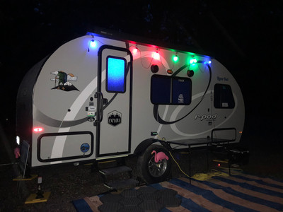
This is BIG park. It covers over 7900 acres and has three lakes ... the biggest of which, Swift Creek Lake, covers 225 acres. The campground has 116 campsites with all of them having electric and water hookups. I stayed in space #3 which is a pull-through site.
This site is located on the first loop of campsites as you enter the camping area. The park (as with most of the Virginia State Park) doesn't have sewer hookups at the campsites but has a dump station near the campground entrance.
The park has more than 64 miles of trails including 5.5 miles of hiking only trails and 25 miles of directional mountain bike trails and 33 miles of multi-use trails suitable for use by hikers, bikers, and equestrians. It is typically a very busy and popular park due to its proximity to Richmond. The park has boating and fishing opportunities on the 3 lakes.
Also in the park are an environmental education center and the Civilian Conservation Corps (CCC) Museum which is housed in an original CCC building. It highlights the many accomplishments of the Corps.
"During its nine-year run, the CCC employed more than 3 million men and left an undeniable imprint on the nation's landscape. The CCC built more than 40,000 bridges, planted two billion trees, restored nearly 4,000 historic sites and structures, improved thousands of beaches, roads and shorelines, and created 800 state parks across America, including six in Virginia."
The Commonwealth is doing a phased reopening, so the State Parks are gradually reopening park facilities as the public health restrictions put in place to contain the spread of COVID-19 are eased, and the visitor centers and museums remain closed at this time. But some of the historic structures remain and are interpreted on the site.
The weather broke and I got a perfect weather day to go kayaking. I brought my new inflatable kayak and went paddling on Swift Creek Lake. The State Parks are not opening any of their swimming pools this summer due to the coronavirus, so the main area of the park (where the pool and boating center are located) was not busy this year. Gasoline motors are prohibited in the lake. So the boat traffic is light. The park does rent kayaks, canoes, and paddleboards on the lake. They had additional protocols in the rental area allowing only one person at a time and sanitizing the boats in between rentals. But I stayed away from that area anyway. I kayaked the length of the lake to the dam spillway and back. About 5.2 miles. The lake was covered on the sides with water lilies in full bloom. Lots of white flowers. There also were yellow lotuses just starting to flower. Lots of birds and tons of turtles out. Simply beautiful scenery and a great paddle. The new kayak performed well and was again easy to set up and take down.
I went hiking around Beaver Lake which is one of the other lakes in the park. The Beaver Lake trail is a 2.5 mile loop around the 24 acre lake. Minimum Elevation: 130 feet. Maximum Elevation: 195 feet. Total climb: 145 feet. Beaver Lake as a cool spillway next to the trail that was flowing pretty strongly.
I also hiked the Powerline and Swift Creek Trails Loop which goes from the road on the southern boundary of the park to the east end of Swift Creek Lake. There is a dam spillway at the turning point of the trail. This is the dam that I kayaked to on the lake. The hike was around 2.9 miles. I found a cool little stream at the base of the dam spillway and was able to walk along the stream bed. Nice little bonus. Definitely worth the hike.
I stayed for 3 nights. The camper towed really well up 460 and I-95 to the park and back. I didn't have any problems despite having rain during both the trip up and the trip back.
As usual, I took WAY too many pictures. I whittled them down and have some posted below.
Stayed tuned for more trips throughout the year. #IntoTheWoodsTour #GoAwayCovid19
Campsite pictures


Beaver Lake Trail


Kayaking on Swift Creek Lake


Powerline and Swift Creek Trail


Comments